Hail & Wind Storms in Terre Haute, IN — Latest Dates and Sizes
Hail and wind activity within ~25 miles of Terre Haute, Indiana or recorded for its county: the last 12 months from NWS warnings, storm reports, and station measurements, plus official NOAA records back to 2010.
Latest hail and wind near Terre Haute
- Last reported hail (0.75 in.+, screening): November 11, 2026 — 1.75 in. reported 6.5 mi SE of Terre Haute (Riley), SPC storm report.
- Last wind gust 45 mph+ (screening): August 13, 2026 — 60 mph reported 6.6 mi N of Terre Haute (2 NW North Terre Haute), NWS Local Storm Report.
- 2026 so far: 4 hail days and 12 wind days within 25 miles (days with a storm report or station gust at the screening thresholds; warnings alone never count).
| Date | Largest reported hail | Strongest gust |
|---|---|---|
| November 11, 2026 | 1.75 in. reported | — |
| August 13, 2026 | — | 60 mph reported |
| August 11, 2026 | 1.50 in. reported | 60 mph reported |
| July 27, 2026 | — | 81 mph reported (Illinois) |
| June 21, 2026 | — | 93 mph reported |
| June 17, 2026 | — | 75 mph reported (Illinois) |
| June 16, 2026 | — | 58 mph reported |
| June 11, 2026 | — | 60 mph reported (Illinois) |
| June 9, 2026 | — | 70 mph reported (Illinois) |
| April 2, 2026 | — | 63 mph reported |
Was your address hit on November 11, 2026? Check any address free with the Free Report Snapshot — a YES/NO estimate at the screening thresholds.
Terre Haute storm facts
- StormAuditor's analysis of NOAA and National Weather Service records found 110 wind and hail events, NWS warning products included, within 25 miles of Terre Haute, Indiana (including the parts of Illinois inside that circle) or recorded for Vigo County in the 12 months ending November 16, 2026 (76 wind, 34 hail).
- The strongest gust within 25 miles of Terre Haute in the last 12 months was 93 mph, reported 19.2 mi S of Terre Haute (Sullivan) on June 21, 2026 (NOAA NCEI Storm Events; storm reports and station gusts only, warnings excluded).
- The largest hail reported within 25 miles of Terre Haute in the last 12 months was 1.75 in., 6.5 mi SE of Terre Haute (Riley) on November 11, 2026 (SPC storm report).
- The busiest day by event count near Terre Haute was June 17, 2026, with 9 events.
- Vigo County alone recorded 74 of those wind and hail events (48 wind, 26 hail); the Indiana page ranks counties by events of every type, floods and Special Weather Statements included.
Terre Haute, Indiana storm history at a glance (last 12 months)
This free weather history for Terre Haute — home to about 59,000 residents — draws on StormAuditor's consolidated public record: 110 wind and hail events within 25 miles of Terre Haute (including the parts of Illinois inside that circle) or recorded for Vigo County in the trailing 12 months — 76 wind and 34 hail.
Events combine NWS warning products, observed Local Storm Reports, station measurements and official NCEI records in one event table. Because they include warnings, and wind covers thunderstorm and non-thunderstorm wind alike, they measure something different from the NCEI entry counts in the history section below; the two are not comparable year to year.
Busiest days near Terre Haute by event count
Ranked by the number of 12-month events, NWS warnings included, so a day with many warnings can outrank a day with larger hail.
- June 17, 2026 — 9 events incl. warnings · 8 wind · 1 hail
- August 20, 2026 — 8 events incl. warnings · 4 wind · 4 hail
- June 21, 2026 — 8 events incl. warnings · 7 wind · 1 hail
- August 13, 2026 — 7 events incl. warnings · 6 wind · 1 hail
- August 11, 2026 — 7 events incl. warnings · 4 wind · 3 hail
How these numbers are counted
The storm numbers on this page are counted in four different ways, plus the free address check. Each answers a different question with its own size cutoffs, area and time span, so compare numbers within one group, not across groups.
- Storm days (latest hail and wind): A day in the last 12 months when at least one report within 25 miles of Terre Haute showed hail 0.75 in. or larger or wind of 45 mph or more (StormAuditor screening thresholds). Reports are NWS storm reports from spotters, the public and officials, plus weather-station gusts, which count from 50 mph. A warning on its own never makes a storm day. The latest and largest hail, the latest and strongest gust, and the storm-day table all use this record. The 25-mile circle around Terre Haute reaches into Illinois. Values marked with that state's name come from there: they count for Terre Haute but not on the Indiana state page, which counts reports inside Indiana only.
- Storm-date pages (NWS severe): A storm-date page is published only when at least one report or station gust within 25 miles of a city met the National Weather Service severe criteria (hail 1.00 in. or larger, or wind 58 mph or more), at least two separate observations were logged, and the day ranks among the most significant. A storm report that relays an airport weather station's reading (the same station, the same gust and the same time) counts once, as the station reading. Not every storm day gets a page; when one does, the page and the storm-day table show the same largest hail and strongest gust.
- Events (12-month counts): Events count NWS warnings, storm reports (wind 50 mph+, hail 0.75 in.+), station gusts (50 mph+) and NCEI entries within 25 miles of Terre Haute or recorded for Vigo County, tornado entries counted as wind. One event is one place on one day, counted separately for hail and for wind. A weather station or storm-report point counts once a day, at that day's highest reading, however many readings it filed; a place with hail and wind on the same day is two events. NWS warnings count once per county per day, and each NCEI entry once per place per day. A storm report that relays an airport weather station's reading (the same station, the same gust and the same time) counts once, as the station reading. The same report arriving through another feed (SPC or NCEI) is one record. Events measure how busy the area was, not whether a storm hit: one storm can bring warnings and reports from many places, so the busiest days by event count can differ from the storm days.
- NOAA history (since 2010): The official NOAA storm record (NCEI Storm Events) within 25 miles of Terre Haute or in Vigo County from January 1, 2010 to the day before the 12-month window starts: hail 0.50 in.+, thunderstorm wind 40 mph+ and tornadoes. It is a separate, older record with its own "storm days" (days with any entry), so its counts are not compared with the 12-month numbers.
- Free Report Snapshot: A free YES/NO estimate for one address, from radar and wind analysis at the property rather than area reports, at the same screening thresholds: hail 0.75 in. or wind 45 mph.
Full method: Methodology and Data Sources.
Terre Haute hail and wind history in NOAA NCEI records, 2010–Nov. 2025
This section covers January 1, 2010 through November 15, 2025. Storms from November 16, 2025 on are in the 12-month summary above, so no date is counted in both.
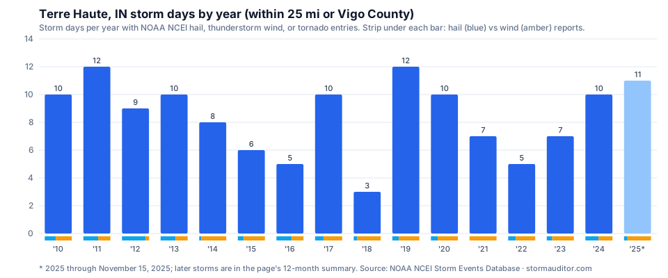
Thunderstorm wind outnumbers hail here: 256 wind reports against 138 hail reports. In all: 409 NCEI Storm Events entries within 25 miles of Terre Haute or in Vigo County, spread over 135 storm days.
On May 16, 2025, 4.00 in. (grapefruit size) hail was reported in Sullivan County — the largest in these records for this area. Hail of 2 inches or more appears in 6 different years of this record, the latest being 2025 through Nov. 15. The strongest measured thunderstorm gust was 75 mph on July 7, 2014 in Clay County. NCEI also lists 15 tornado entries for the area — one entry per county a tornado crossed.
Hail peaks in April (26% of all hail reports), while thunderstorm wind reports cluster in June. December through February accounts for 7 storm days.
The most storm days came in 2011 and 2019, with 12 each; the fewest in a full year was 3, in 2018. Across 2022–2024, the area averaged 7.3 storm days a year, below the 15-year average of 8.3.
- Average: 8.3 storm days a year (2010–2024)
- April and May: 51% of all hail reports
- Most hail reports in one year: 23 in 2011
- Hail of 1 in. or larger reported in 13 of 15 full years (2010–2024)
| Year | Hail reports | Thunderstorm wind reports | Tornado entries | Storm days | Largest hail | Strongest measured gust |
|---|---|---|---|---|---|---|
| 2010 | 14 | 20 | 0 | 10 | 1.75 in. | 70 mph |
| 2011 | 23 | 19 | 3 | 12 | 1.75 in. | 63 mph |
| 2012 | 20 | 3 | 1 | 9 | 1.75 in. | — |
| 2013 | 11 | 9 | 2 | 10 | 2.50 in. | 60 mph |
| 2014 | 1 | 12 | 0 | 8 | 1.75 in. | 75 mph |
| 2015 | 2 | 7 | 0 | 6 | 1.00 in. | 60 mph |
| 2016 | 13 | 10 | 0 | 5 | 2.50 in. | — |
| 2017 | 6 | 13 | 0 | 10 | 1.00 in. | — |
| 2018 | 1 | 7 | 0 | 3 | 0.75 in. | — |
| 2019 | 6 | 19 | 0 | 12 | 2.50 in. | 60 mph |
| 2020 | 9 | 27 | 0 | 10 | 2.00 in. | — |
| 2021 | 0 | 24 | 0 | 7 | — | 62 mph |
| 2022 | 4 | 10 | 0 | 5 | 1.00 in. | — |
| 2023 | 8 | 32 | 0 | 7 | 2.00 in. | — |
| 2024 | 16 | 17 | 0 | 10 | 1.75 in. | 59 mph |
| 2025 through Nov. 15 | 4 | 27 | 9 | 11 | 4.00 in. | 64 mph |
Download this history: CSV · JSON at https://www.stormauditor.com/downloads/storm-history/in/terre-haute.json (free, open license, cite StormAuditor).
Source: NOAA NCEI Storm Events Database (thunderstorm wind, hail, and tornado entries; hail 0.50 in. or larger, wind 40 mph or more; wind converted from knots).
Terre Haute storm history questions, 2010–Nov. 2025
How big did hail get in Terre Haute, 2010–Nov. 2025?
4.00 in., grapefruit size, reported on May 16, 2025 in Sullivan County, per NCEI. Hail of 2 inches or more appears in 6 years of this record in all, most recently 2019, 2020 and 2023.
Which year had the most storm days near Terre Haute, 2010–Nov. 2025?
2011 and 2019 tied, with 12 storm days each. The 15-year average is 8.3 storm days.
How many hail reports does Terre Haute see in a typical year?
About 8.9 hail reports a year (2010–2024 average), with 1-inch or larger hail in 13 of 15 years. Thunderstorm wind averages 15 reports a year.
What month has the most hail near Terre Haute?
April has the most hail reports (36, 2010–Nov. 2025), followed by May (34) and March (29).
What is the strongest measured thunderstorm gust near Terre Haute, 2010–Nov. 2025?
75 mph, measured on July 7, 2014 in Clay County. Only gusts NCEI lists as measured count here; gusts measured on a date and county with a tornado entry, and entries of 120 knots or more (known entry errors), are left out.
Terre Haute hail map and wind map
Researching hail or wind in Terre Haute? The Hail Explorer and Wind Explorer map radar-derived hail swaths and peak-gust wind swaths across Indiana, including the Terre Haute metro: pick any storm date and see how estimated hail size and gust bands tracked through Vigo County. Both explorers are included with Pro+ and Organization plans.
County-level activity is on the Impact Heatmap (free with an account), and day-by-day history is on the Storm Calendar (Pro plans and higher).
Free Terre Haute weather report by address
Area maps show where storms tracked; an insurance claim or roof inspection turns on what happened at the property. Three ways to check one Terre Haute address:
- The Free Report Snapshot answers YES/NO instantly on estimated wind of 45 mph or more and hail of 0.75 in. or larger (screening thresholds) at the address.
- The free Address Lookup lists NWS warnings, storm reports and NOAA observations near the address — free Terre Haute wind history and free Terre Haute hail history.
- A complete Weather Report for $2.99 covers every qualifying storm date at one address since October 2021.
All values are estimates from public NOAA data under our published methodology (see Limitations).
For roofers, adjusters, and claim attorneys: the professional tools add statewide hail and wind swath maps, the Zone Canvas Tool, and Audit Reports with the evidence and arithmetic — see how roofing contractors and insurance claim attorneys use them.
Sources: NWS alerts (api.weather.gov) · NWS Local Storm Reports via the Iowa Environmental Mesonet · ASOS/AWOS station gusts via the Iowa Environmental Mesonet · NOAA NCEI Storm Events Database · every StormAuditor data source.
Free Terre Haute storm data download
The Terre Haute storm records for the last 12 months download free, free to reuse under the data license: download CSV · JSON at https://www.stormauditor.com/downloads/storm-data/in/terre-haute.json.
- Coverage: every wind and hail record within about 25 miles of Terre Haute (including the parts of Illinois inside that circle) or recorded for Vigo County, with dates, counties, event types, measured gusts and hail sizes.
- Rows: each source record before consolidation, including every NWS warning product and smaller storm reports, so the row count differs from the event counts above. The file holds Indiana records only; the counts above also include the neighboring-state records inside the 25-mile circle.
- Statewide files are on the Indiana storm data page.
Nearby city storm pages:
- Charleston, IL hail & wind history
- Danville, IL hail & wind history
- Bloomington hail & wind history
- Vincennes hail & wind history
- Urbana, IL hail & wind history
- Champaign, IL hail & wind history
- Indiana statewide storm data
Guides for reading this data
Cite or link to this data — free
Free to quote, summarize, reuse, and link — for bloggers, journalists, researchers, contractors, and AI writing tools. No permission or credit required. A ready-made citation and link are below if they help. Terms: StormAuditor data & content license.
Citation: StormAuditor. "Terre Haute, IN Hail & Wind Storm History." Updated November 11, 2026. https://www.stormauditor.com/storm-data/in/terre-haute
HTML link: <a href="https://www.stormauditor.com/storm-data/in/terre-haute">Terre Haute, IN Hail & Wind Storm History — StormAuditor</a>
About this page: built by Storm Auditor LLC from public NOAA/NWS records — deduplicated warnings, storm reports, station measurements, and official records on a rolling 12-month window, under the published methodology. See the StormAuditor Editorial Team for how content is produced.
Data last refreshed November 16, 2026. Event counts cover wind and hail (warning products, and storm reports from 50 mph or 0.75 in.); flood activity and Special Weather Statements are not counted here.